


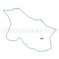
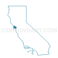
Voting District 20105, Marin County, California
About
Outline

Summary
| Unique Area Identifier | 534837 |
| Name | Voting District 20105 |
| County | Marin County |
| State | California |
| Area (square miles) | 1.19 |
| Land Area (square miles) | 1.19 |
| Water Area (square miles) | 0.00 |
| % of Land Area | 100.00 |
| % of Water Area | 0.00 |
| Latitude of the Internal Point | 37.96540450 |
| Longtitude of the Internal Point | -122.56100320 |
Maps

Graphs
Select a template below for downloading or customizing gragh for Voting District 20105, Marin County, California


Neighbors
Neighoring Voting District (by Name) Neighboring Voting District on the Map
- Voting District 10020, Marin County, CA
- Voting District 20055, Marin County, CA
- Voting District 20100, Marin County, CA
- Voting District 20120, Marin County, CA
- Voting District 20130, Marin County, CA
- Voting District 20131, Marin County, CA
- Voting District 20140, Marin County, CA
- Voting District 20141, Marin County, CA
- Voting District 40355, Marin County, CA
Top 10 Neighboring County Subdivision (by Population) Neighboring County Subdivision on the Map
Top 10 Neighboring Place (by Population) Neighboring Place on the Map
- San Rafael city, CA (57,713)
- San Anselmo town, CA (12,336)
- Kentfield CDP, CA (6,485)
- Ross town, CA (2,415)
Top 10 Neighboring Elementary School District (by Population) Neighboring Elementary School District on the Map
- San Rafael City Elementary School District, CA (54,884)
- Ross Valley Elementary School District, CA (23,470)
- Kentfield Elementary School District, CA (11,396)
- Ross Elementary School District, CA (2,711)
Top 10 Neighboring Secondary School District (by Population) Neighboring Secondary School District on the Map
- Tamalpais Union High School District, CA (113,295)
- San Rafael City High School District, CA (76,180)
Top 10 Neighboring State Legislative District Lower Chamber (by Population) Neighboring State Legislative District Lower Chamber on the Map
Top 10 Neighboring State Legislative District Upper Chamber (by Population) Neighboring State Legislative District Upper Chamber on the Map
Top 10 Neighboring 111th Congressional District (by Population) Neighboring 111th Congressional District on the Map
Top 10 Neighboring Census Tract (by Population) Neighboring Census Tract on the Map
- Census Tract 1110, Marin County, CA (5,852)
- Census Tract 1141, Marin County, CA (5,133)
- Census Tract 1191, Marin County, CA (4,609)
- Census Tract 1170, Marin County, CA (4,527)
- Census Tract 1181, Marin County, CA (2,407)
- Census Tract 1311, Marin County, CA (1,038)